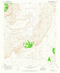
1964 Map of Cerro Del Oro
USGS Topo · Published 1967About this map
Cerro del Oro rises as the central landmark of this high-desert region, overlooking a landscape defined by an intricate network of water-management features essential for ranching in the mid-1960s. The map illustrates a reliance on numerous tanks and springs to support life in the arid environment of New Mexico. Named sites like the Seis-Wilson Ranch and Orchard Place represent the established cattle-raising operations of the era, while topographic features such as Gun Mesa and Arroyo Blanco provide natural boundaries for these lands.
Find a feature on this map
34 named features on this map. Tap any name to fly to it.
Don’t see what you’re looking for? This feature index may not catch every label — zoom into the map to look around manually.
Map Details
Editions of this 1964 Cerro Del Oro Map
This is the sole edition of this map. No revisions or reprints were ever made.
Other maps of this area

1917 · Cerro Verde
USGS Topo · 1:125,000

1917 · Broom Mountain
USGS Topo · 1:125,000

1954 · Socorro
USGS Topo · 1:250,000

1958 · Socorro
USGS Topo · 1:250,000

1960 · Cerro Verde
USGS Topo · 1:24,000

1961 · Marmon Ranch
USGS Topo · 1:24,000
1961 · East Mesa
USGS Topo · 1:24,000

1962 · Socorro
USGS Topo · 1:250,000

1964 · Field Ranch
USGS Topo · 1:24,000
1964 · Chicken Mountain
USGS Topo · 1:24,000