
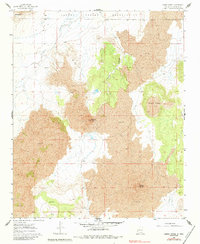
1960 Map of Cerro Verde
USGS Topo · Published 1963About this map
The northern edge of the Laguna Indian Reservation meets a stark volcanic landscape in this 1960s study of New Mexico's basalt-covered terrain. Significant geologic features dominate the topography, including the prominent volcanic cone of Cerro Verde and the isolated plateau of Black Mesa. The presence of Volcano Hill and extensive lava flows illustrates the volcanic history that shaped this part of Valencia County. Human infrastructure is sparse, limited to vital water resources necessary for ranching in an arid environment. Locations like the Homestead Windmill and Rock Tank Windmill, alongside a secluded Spring, indicate the primary points of activity and survival in the high desert. To the northwest, the peak of Tsidu-Weza stands as a landmark overlooking the drainage of Poncho Canyon, providing a clear view of the geologic and cultural boundaries of the era.
Find a feature on this map
11 named features on this map. Tap any name to fly to it.
Don’t see what you’re looking for? This feature index may not catch every label — zoom into the map to look around manually.
Map Details
Editions of this 1960 Cerro Verde Map
2 editions found
Other maps of this area

1917 · Cerro Verde
USGS Topo · 1:125,000

1954 · Socorro
USGS Topo · 1:250,000

1956 · South Garcia
USGS Topo · 1:62,500

1956 · Mesa Aparejo
USGS Topo · 1:62,500

1958 · Socorro
USGS Topo · 1:250,000
1960 · South Butte
USGS Topo · 1:24,000
1960 · Dough Mountain
USGS Topo · 1:24,000

1961 · Marmon Ranch
USGS Topo · 1:24,000

1962 · Socorro
USGS Topo · 1:250,000
1964 · Cerro Del Oro
USGS Topo · 1:24,000