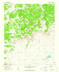
1960 Map of South Butte
USGS Topo · Published 1963About this map
The Laguna Indian Reservation landscape is defined by its dramatic mesas and isolated buttes, as mapped in this early 1960s survey. Key topographic landmarks like North Butte and South Butte rise above the Southwest Passage, providing a clear view of the natural corridors used for movement across this arid territory. The presence of several named water sources, such as Turquoise Spring, Coyote Spring, and Kemp Santiago Spring, highlights the critical importance of reliable water in the high desert.
Find a feature on this map
24 named features on this map. Tap any name to fly to it.
Don’t see what you’re looking for? This feature index may not catch every label — zoom into the map to look around manually.
Map Details
Editions of this 1960 South Butte Map
2 editions found
Other maps of this area

1883 · Mt. Taylor
USGS Topo · 1:250,000

1886 · Mt. Taylor
USGS Topo · 1:250,000

1892 · Mt. Taylor
USGS Topo · 1:250,000

1899 · Mt. Taylor
USGS Topo · 1:250,000

1917 · Cerro Verde
USGS Topo · 1:125,000

1917 · Broom Mountain
USGS Topo · 1:125,000

1954 · Socorro
USGS Topo · 1:250,000

1957 · Laguna
USGS Topo · 1:24,000

1957 · Cubero
USGS Topo · 1:24,000

1957 · Mesita
USGS Topo · 1:24,000