
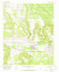
1957 Map of Laguna
USGS Topo · Published 1959About this map
Laguna Indian Reservation lands dominate this mid-century landscape, centered on the ancient and modern Pueblo settlements along the Rio San Jose. The village of Laguna serves as a focal point, featuring the San Jose Mission and proximity to the Atchison Topeka and Santa Fe Railroad, which parallels the river valley. To the west, the community of Paraje is shown with its own St Margaret-Mary Ch and a nearby Paraje Irrigation Ditch, illustrating the area's reliance on the seasonal water of Encinal Creek.
Find a feature on this map
51 named features on this map. Tap any name to fly to it.
Don’t see what you’re looking for? This feature index may not catch every label — zoom into the map to look around manually.
Map Details
Editions of this 1957 Laguna Map
2 editions found
Other maps of this area

1883 · Mt. Taylor
USGS Topo · 1:250,000

1886 · Mt. Taylor
USGS Topo · 1:250,000

1892 · Mt. Taylor
USGS Topo · 1:250,000

1899 · Mt. Taylor
USGS Topo · 1:250,000

1917 · Cerro Verde
USGS Topo · 1:125,000

1917 · Broom Mountain
USGS Topo · 1:125,000

1954 · Socorro
USGS Topo · 1:250,000

1957 · Mount Taylor
USGS Topo · 1:24,000

1957 · Moquino
USGS Topo · 1:24,000

1957 · Cubero
USGS Topo · 1:24,000