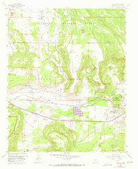
1957 Map of Laguna
USGS Topo · Published 1973About this map
Laguna Indian Reservation lands dominate this mid-century landscape, where the Rio San Jose carves a valley between massive mesas. The settlement pattern follows the life-giving water, with Encinal nestled at the base of Wheat Mountain and the villages of Paraje and Casa Blanca situated along the Casa Blanca Ditch. The 1971 photorevisions capture subtle shifts in the region, noting modern developments alongside the ancient San Jose Mission and St Margaret Mary Ch. Industrial and transport infrastructure, such as the Atchison Topeka and Santa Fe Railroad and the Gypsum Landing Strip, highlight the intersection of traditional Pueblo life with the commercial needs of the era. The terrain itself is a character here, ranging from the Sand Dunes in the southeast to the flat-topped Frog Mesa and Casa Blanca Mesa.
Find a feature on this map
45 named features on this map. Tap any name to fly to it.
Don’t see what you’re looking for? This feature index may not catch every label — zoom into the map to look around manually.
Map Details
Editions of this 1957 Laguna Map
2 editions found
Other maps of this area

1883 · Mt. Taylor
USGS Topo · 1:250,000

1886 · Mt. Taylor
USGS Topo · 1:250,000

1892 · Mt. Taylor
USGS Topo · 1:250,000

1899 · Mt. Taylor
USGS Topo · 1:250,000

1917 · Cerro Verde
USGS Topo · 1:125,000

1917 · Broom Mountain
USGS Topo · 1:125,000

1954 · Socorro
USGS Topo · 1:250,000

1957 · Mount Taylor
USGS Topo · 1:24,000

1957 · Laguna
USGS Topo · 1:24,000

1957 · Moquino
USGS Topo · 1:24,000