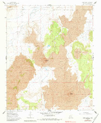
1960 Map of Cerro Verde
USGS Topo · Published 1984About this map
The Laguna Indian Reservation occupies the northern reaches of this New Mexico landscape, dominated by extensive volcanic formations. Massive deposits of Lava define the terrain, punctuated by prominent features such as Black Mesa, Volcano Hill, and the eponymous Cerro Verde in the southeast. This survey, grounded in 1951 aerial photography and field-checked in 1960, illustrates a geological transition where drainage patterns like Arroyo Colorado and Arroyo Lucero navigate the basaltic flows. Water sources are scarce in this arid environment, marked only by isolated features like a Spring and the Rock Tank with its accompanying Windmill. These small infrastructure points provided critical support for ranching or land management within the reservation and surrounding public lands before more modern development reached the area.
Find a feature on this map
15 named features on this map. Tap any name to fly to it.
Don’t see what you’re looking for? This feature index may not catch every label — zoom into the map to look around manually.
Map Details
Editions of this 1960 Cerro Verde Map
2 editions found
Other maps of this area

1917 · Cerro Verde
USGS Topo · 1:125,000

1954 · Socorro
USGS Topo · 1:250,000

1956 · South Garcia
USGS Topo · 1:62,500

1956 · Mesa Aparejo
USGS Topo · 1:62,500

1958 · Socorro
USGS Topo · 1:250,000
1960 · South Butte
USGS Topo · 1:24,000
1960 · Dough Mountain
USGS Topo · 1:24,000

1960 · Cerro Verde
USGS Topo · 1:24,000

1961 · Marmon Ranch
USGS Topo · 1:24,000

1962 · Socorro
USGS Topo · 1:250,000