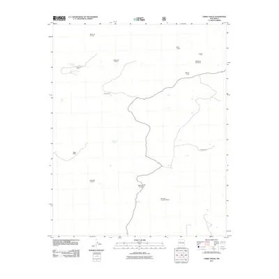
2011 Map of Cerro Tinaja
USGS Topo · Published 2011About this map
Juan Jose Ranch and Sanchez Ranch anchor this high-desert landscape in Sandoval County, illustrating the persistence of land-grant legacies and family ranching in northern New Mexico. The terrain is defined by dramatic mesas and volcanic features, including the prominent Cerro Tinaja and the dark profile of Black Mesa. These elevations are carved by deep drainage systems like Jaramosa Canyon and Badlands Canyon, which reveal the complex geology of the Jemez region. Critical water sources, such as Rancho Viejo Spring and Ojo Canoa, dictate the placement of human activity and livestock grazing in this arid environment. The map provides a detailed view of the winding trackways and traditional land uses at Rancho Viejo and the Gonzales Ranch, where the names of mesas like Mesita de la Ventana and Mesita Leon reflect a long history of local geographic naming.
Find a feature on this map
17 named features on this map. Tap any name to fly to it.
Don’t see what you’re looking for? This feature index may not catch every label — zoom into the map to look around manually.
Map Details
Editions of this 2011 Cerro Tinaja Map
This is the sole edition of this map. No revisions or reprints were ever made.
Other maps of this area

1883 · Mt. Taylor
USGS Topo · 1:250,000

1886 · Mt. Taylor
USGS Topo · 1:250,000

1892 · Mt. Taylor
USGS Topo · 1:250,000

1899 · Mt. Taylor
USGS Topo · 1:250,000

1958 · Albuquerque
USGS Topo · 1:250,000

1961 · Marquez
USGS Topo · 1:24,000

1961 · Cerro Parido
USGS Topo · 1:24,000

1961 · Cerro Tinaja
USGS Topo · 1:24,000
1961 · La Gotera
USGS Topo · 1:24,000
1961 · Puerco Dam
USGS Topo · 1:24,000