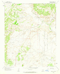
1961 Map of Puerco Dam
USGS Topo · Published 1963About this map
Rio Puerco carves a path through the northeastern portion of this landscape, its course marked by the remnant structures of the Puerco Dam (Ruin) and the notable Cuervo Crossing. The terrain is defined by a complex network of dry washes and arroyos, including Arroyo Cuervo and Arroyo Nine, which drain the expansive plateaus and mesas. Large tracts of the area are dedicated to the Laguna Indian Reservation and the historical land grant of Nuestra Señora de la Luz de las Lagunitas. Isolated outposts like Las Lagunitas Ranch and the small settlement at Nervio reflect the sparse, ranch-driven settlement patterns of the early 1960s. Scattered Prospects in the southern reaches, specifically near Cañada de los Alamos, indicate localized exploration for mineral resources within this arid New Mexico environment.
Find a feature on this map
22 named features on this map. Tap any name to fly to it.
Don’t see what you’re looking for? This feature index may not catch every label — zoom into the map to look around manually.
Map Details
Editions of this 1961 Puerco Dam Map
2 editions found
Other maps of this area

1883 · Mt. Taylor
USGS Topo · 1:250,000

1886 · Mt. Taylor
USGS Topo · 1:250,000

1888 · Bernalillo
USGS Topo · 1:125,000

1889 · Albuquerque
USGS Topo · 1:125,000

1892 · Mt. Taylor
USGS Topo · 1:250,000

1893 · Albuquerque
USGS Topo · 1:125,000

1899 · Mt. Taylor
USGS Topo · 1:250,000

1954 · Herrera
USGS Topo · 1:24,000

1954 · Sky Village
USGS Topo · 1:24,000
1954 · Benavidez Ranch
USGS Topo · 1:24,000