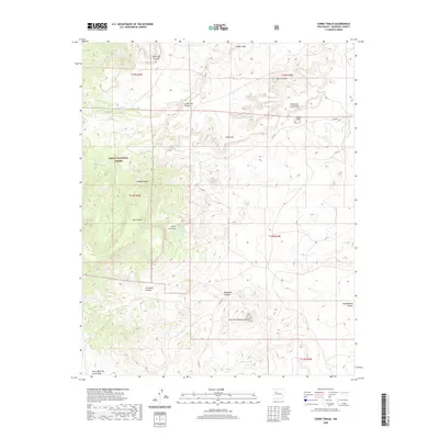
2020 Map of Cerro Tinaja
USGS Topo · Published 2020About this map
Cibola National Forest defines the western terrain of this Sandoval County landscape, where the high desert is marked by volcanic formations and seasonal water sources. The topography is dominated by massive landforms like Black Mesa and the volcanic plug of Cerro de Nuestra Señora, rising above the intricate drainage networks of Badlands Canyon and Jaramosa Canyon. This 2020 record of the region captures a series of critical water points in an arid environment, including Rancho Viejo Spring, Jara Loso Spring, and Jaralosa Spring. These features, along with the numerous canyons like Cañada Nervio and Cañon del Puente, illustrate the complex erosion patterns and traditional land management boundaries of the New Mexico interior. The map clearly delineates the section lines of the Public Land Survey System, providing a framework for understanding the vast, uninhabited expanses of the Cibola National Forest.
Find a feature on this map
27 named features on this map. Tap any name to fly to it.
Don’t see what you’re looking for? This feature index may not catch every label — zoom into the map to look around manually.
Map Details
Editions of this 2020 Cerro Tinaja Map
This is the sole edition of this map. No revisions or reprints were ever made.
Other maps of this area

1883 · Mt. Taylor
USGS Topo · 1:250,000

1886 · Mt. Taylor
USGS Topo · 1:250,000

1892 · Mt. Taylor
USGS Topo · 1:250,000

1899 · Mt. Taylor
USGS Topo · 1:250,000

1958 · Albuquerque
USGS Topo · 1:250,000

1961 · Marquez
USGS Topo · 1:24,000

1961 · Cerro Parido
USGS Topo · 1:24,000

1961 · Cerro Tinaja
USGS Topo · 1:24,000
1961 · La Gotera
USGS Topo · 1:24,000
1961 · Puerco Dam
USGS Topo · 1:24,000