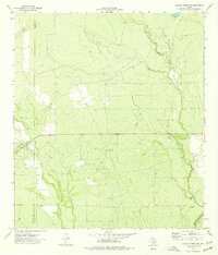
1974 Map of Chacon Creek NE
USGS Topo · Published 1977About this map
Chaparrosa Creek and Palo Blanco Creek wind through the arid landscape of the south Texas brush country in this mid-1970s survey. The map records the sparse but active industrial and transit network of the area, straddling the Maverick Co and Zavala Co line. Numerous Gas Wells and scattered livestock wells suggest an economy deeply tied to resource extraction and ranching, while a remote Landing Strip and a Gravel Pit indicate the logistical infrastructure required to maintain these operations in a region characterized by intermittent waterways like Dinner Creek and Mula Creek.
Find a feature on this map
10 named features on this map. Tap any name to fly to it.
Don’t see what you’re looking for? This feature index may not catch every label — zoom into the map to look around manually.
Map Details
Editions of this 1974 Chacon Creek NE Map
This is the sole edition of this map. No revisions or reprints were ever made.
Other maps of this area

1896 · Brackett
USGS Topo · 1:125,000

1897 · Brackett
USGS Topo · 1:125,000

1898 · Uvalde
USGS Topo · 1:125,000

1899 · Uvalde
USGS Topo · 1:125,000

1939 · La Pryor
USGS Topo · 1:62,500

1940 · Chacon Creek
USGS Topo · 1:62,500

1949 · Cline
USGS Topo · 1:62,500

1953 · Crystal City
USGS Topo · 1:250,000

1954 · San Antonio
USGS Topo · 1:250,000

1955 · Crystal City
USGS Topo · 1:250,000