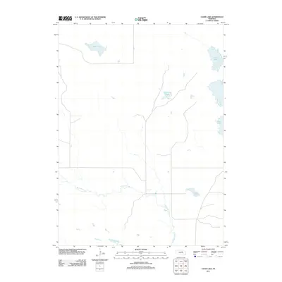
2011 Map of Chain Lake
USGS Topo · Published 2011About this map
Big Cedar Creek meanders through this portion of Nebraska, defining a landscape dominated by its hydrologic network. The region is characterized by several distinct water bodies, including the elongated Chain Lake and the isolated Willow Lake in the northwest. This 2011 survey captures the area's geography as it was managed by the U.S. Geological Survey and the Department of the Interior. The sparse placement of structures and the presence of names like Sunfish Lake, Rush Lake, and Clark Lake suggest a rural, agrarian environment where water sources serve as primary geographic anchors. The map reflects a modern period of topographic record-keeping, utilizing data from the National Hydrography Dataset and NAIP imagery to provide a precise account of the creek's path and the surrounding lakeshore boundaries.
Find a feature on this map
6 named features on this map. Tap any name to fly to it.
Don’t see what you’re looking for? This feature index may not catch every label — zoom into the map to look around manually.
Map Details
Editions of this 2011 Chain Lake Map
This is the sole edition of this map. No revisions or reprints were ever made.
Other maps of this area

1952 · Burwell NE
USGS Topo · 1:24,000

1954 · Gables NW
USGS Topo · 1:24,000

1954 · Gables
USGS Topo · 1:24,000

1955 · Broken Bow
USGS Topo · 1:250,000

1955 · O'Neill
USGS Topo · 1:250,000

1956 · Broken Bow
USGS Topo · 1:250,000

1959 · O'Neill
USGS Topo · 1:250,000

1969 · O'Neill
USGS Topo · 1:250,000
1981 · Abbott Ranch
USGS Topo · 1:24,000

1981 · Swan Lake
USGS Topo · 1:24,000