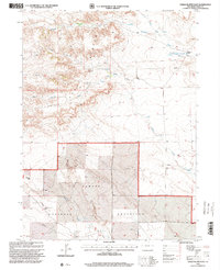
1997 Map of Chalk Bluffs East
USGS Topo · Published 2000About this map
Pawnee National Grassland dominates this corner of Weld County, where the high plains break into the dramatic escarpment of the Chalk Bluffs. This landscape is defined by its sparse water sources and ranching infrastructure, as seen in the network of windmills and wells like Canyon Windmill and Sauer Well. Cattle ranching is anchored at the Eagle Rock Ranch in the northeast, while the terrain's geological character is highlighted by landmarks such as Squaw Rock. Natural drainage flows through the North Fork and Simpson Creek, supporting occasional Springs that were vital for survival in this arid environment. The map also records the modern industrial footprint of several Pipeline corridors cutting across the prairie, reflecting the intersection of public land management and resource extraction in the late twentieth century.
Find a feature on this map
21 named features on this map. Tap any name to fly to it.
Don’t see what you’re looking for? This feature index may not catch every label — zoom into the map to look around manually.
Map Details
Editions of this 1997 Chalk Bluffs East Map
This is the sole edition of this map. No revisions or reprints were ever made.
Other maps of this area

1908 · Eaton
USGS Topo · 1:125,000

1910 · Eaton
USGS Topo · 1:125,000

1911 · Cheyenne
USGS Topo · 1:125,000

1914 · Cheyenne
USGS Topo · 1:125,000

1954 · Cheyenne
USGS Topo · 1:250,000

1954 · Greeley
USGS Topo · 1:250,000

1957 · Greeley
USGS Topo · 1:250,000

1958 · Cheyenne
USGS Topo · 1:250,000

1958 · Greeley
USGS Topo · 1:250,000

1961 · Greeley
USGS Topo · 1:250,000