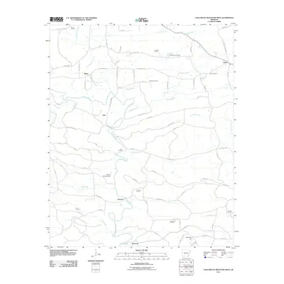
2011 Map of Chalybeate Mountain West
USGS Topo · Published 2011About this map
The Antoine River carves a winding path through this corner of Clark County, anchoring a rural landscape defined by historic settlements and numerous family burying grounds. Small communities such as Graysonia, Shawmut, and Nutts are linked by a network of backroads and creek crossings, including the notable Twin Bridges. The area's genealogical depth is evident in the high density of memorial sites, from the Osborn Cemetery in the north to the Straightway Cemetery near the southern boundary.
Find a feature on this map
84 named features on this map. Tap any name to fly to it.
Don’t see what you’re looking for? This feature index may not catch every label — zoom into the map to look around manually.
Map Details
Editions of this 2011 Chalybeate Mountain West Map
This is the sole edition of this map. No revisions or reprints were ever made.
Other maps of this area

1906 · Caddo Gap
USGS Topo · 1:125,000

1936 · Glenwood
USGS Topo · 1:48,000

1942 · Glenwood
USGS Topo · 1:62,500

1943 · Antoine
USGS Topo · 1:62,500

1949 · Glenwood
USGS Topo · 1:62,500

1955 · Little Rock
USGS Topo · 1:250,000

1956 · Little Rock
USGS Topo · 1:250,000

1960 · Little Rock
USGS Topo · 1:250,000

1964 · Little Rock
USGS Topo · 1:250,000
1966 · Point Cedar
USGS Topo · 1:24,000