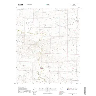
2020 Map of Chalybeate Mountain West
USGS Topo · Published 2020About this map
Graysonia sits at the southern edge of this Arkansas landscape, where the Antoine River cuts a winding path through the borderlands of Clark and Pike counties. The area is defined by a series of small, dispersed settlements including Shawmut, Nutts, and Majors, each connected by a network of rural routes like Old Hot Spring Rd and Center Ridge Rd. The terrain is punctuated by significant elevations such as Chalybeate Mtn and Round Top Mtn, which overlook a watershed drained by numerous creeks including Little Antoine Cr, Skipper Cr, and Gentry Cr.
Find a feature on this map
102 named features on this map. Tap any name to fly to it.
Don’t see what you’re looking for? This feature index may not catch every label — zoom into the map to look around manually.
Map Details
Editions of this 2020 Chalybeate Mountain West Map
This is the sole edition of this map. No revisions or reprints were ever made.
Other maps of this area

1906 · Caddo Gap
USGS Topo · 1:125,000

1936 · Glenwood
USGS Topo · 1:48,000

1942 · Glenwood
USGS Topo · 1:62,500

1943 · Antoine
USGS Topo · 1:62,500

1949 · Glenwood
USGS Topo · 1:62,500

1955 · Little Rock
USGS Topo · 1:250,000

1956 · Little Rock
USGS Topo · 1:250,000

1960 · Little Rock
USGS Topo · 1:250,000

1964 · Little Rock
USGS Topo · 1:250,000
1966 · Point Cedar
USGS Topo · 1:24,000