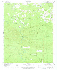
1975 Map of Chalybeate Mtn West
USGS Topo · Published 1978About this map
The Antoine River carves a winding path through the borderlands of Clark and Pike Counties, anchoring a landscape defined by timber, small settlements, and mining. In the mid-1970s, the rural character of this region is evident in the cluster of community landmarks around Alpine, where Alpine Cem and Gardner Cem sit near the ridge lines. Further south, the map details the layout of Graysonia and its namesake Graysonia Cem, positioned near the Missouri Pacific River corridor. The terrain is marked by the prominent Chalybeate Mountain and Round Top Mountain, with numerous resource extraction points noted simply as Mines. This survey documents a network of rural roads such as Shawmut Road and Skyline Drive that connect isolated churches like Friendship Ch and Center Ridge Ch, providing a detailed look at the social and industrial geography of southwest Arkansas during this era.
Find a feature on this map
41 named features on this map. Tap any name to fly to it.
Don’t see what you’re looking for? This feature index may not catch every label — zoom into the map to look around manually.
Map Details
Editions of this 1975 Chalybeate Mtn West Map
This is the sole edition of this map. No revisions or reprints were ever made.
Other maps of this area

1906 · Caddo Gap
USGS Topo · 1:125,000

1936 · Glenwood
USGS Topo · 1:48,000

1942 · Glenwood
USGS Topo · 1:62,500

1943 · Antoine
USGS Topo · 1:62,500

1949 · Glenwood
USGS Topo · 1:62,500

1955 · Little Rock
USGS Topo · 1:250,000

1956 · Little Rock
USGS Topo · 1:250,000

1960 · Little Rock
USGS Topo · 1:250,000

1964 · Little Rock
USGS Topo · 1:250,000
1966 · Point Cedar
USGS Topo · 1:24,000