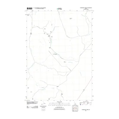
2011 Map of Champagne Creek
USGS Topo · Published 2011About this map
Mining operations and narrow canyons define this stretch of Butte County, where the high desert terrain meets the foothills of the Pioneer Mountains. The landscape is marked by a legacy of extraction, notably around Saint Louis Canyon and Poison Gulch, where several claims including the Reliance Mine, Oxide Lode Mine, and Last Chance Mine are clustered. These workings reflect the silver and lead mining history that once spurred the establishment of small settlements like Era and Martin, which served as local hubs for the prospectors and ranchers of the era.
Find a feature on this map
33 named features on this map. Tap any name to fly to it.
Don’t see what you’re looking for? This feature index may not catch every label — zoom into the map to look around manually.
Map Details
Editions of this 2011 Champagne Creek Map
This is the sole edition of this map. No revisions or reprints were ever made.
Other maps of this area

1935 · MacKay
USGS Topo · 1:96,000

1955 · Idaho Falls
USGS Topo · 1:250,000

1958 · Idaho Falls
USGS Topo · 1:250,000

1960 · Grouse
USGS Topo · 1:62,500

1972 · Nichols Reservoir
USGS Topo · 1:24,000

1972 · Inferno Cone
USGS Topo · 1:24,000

1972 · Blizzard Mtn South
USGS Topo · 1:24,000

1972 · Appendicitis Hill
USGS Topo · 1:24,000
1973 · The Watchman
USGS Topo · 1:24,000

1978 · Craters Of The Moon
USGS Topo · 1:100,000