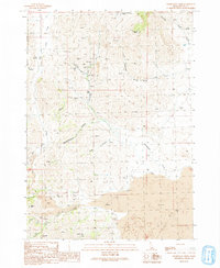
1991 Map of Champagne Creek
USGS Topo · Published 1991About this map
Mining history defines the landscape of the southern Pioneer Mountains in this 1991 survey, particularly around the vanished settlement at Era (Site). Situated along Champagne Creek, this area was once a center of silver and base-metal extraction. A dense cluster of claims is recorded here, including the Horn Silver Mine, Ella Mine, Reliance Mine, and the Saint Louis Mine. The proximity of these workings to geographic landmarks like Poison Gulch and Slaughterhouse Canyon illustrates the intensity of prospector activity across the rugged slopes of Timbered Dome.
Find a feature on this map
37 named features on this map. Tap any name to fly to it.
Don’t see what you’re looking for? This feature index may not catch every label — zoom into the map to look around manually.
Map Details
Editions of this 1991 Champagne Creek Map
This is the sole edition of this map. No revisions or reprints were ever made.
Other maps of this area

1935 · MacKay
USGS Topo · 1:96,000

1955 · Idaho Falls
USGS Topo · 1:250,000

1958 · Idaho Falls
USGS Topo · 1:250,000

1960 · Grouse
USGS Topo · 1:62,500

1972 · Nichols Reservoir
USGS Topo · 1:24,000

1972 · Inferno Cone
USGS Topo · 1:24,000

1972 · Blizzard Mtn South
USGS Topo · 1:24,000

1972 · Appendicitis Hill
USGS Topo · 1:24,000
1973 · The Watchman
USGS Topo · 1:24,000

1978 · Craters Of The Moon
USGS Topo · 1:100,000