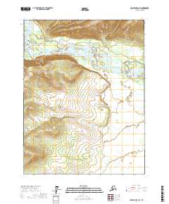
2017 Map of Chandalar A-1 SE
USGS Topo · Published 2017About this map
The Teedriinjik River flows across this subarctic landscape, carving a wide alluvial path through the northern Yukon-Koyukuk region. In the northwestern corner of this quadrangle, the East Fork Chandalar River joins the drainage system near the prominent rise of the Chuttoh Bluffs. These bluffs represent a significant topographic landmark in an otherwise complex network of braided river channels and shifting sandbars. The map detail reflects the untamed character of the Alaskan interior in the early 21st century, where the absence of roads or permanent settlements emphasizes a landscape defined entirely by its hydrography and elevation. Researchers of northern geography can trace the intricate meanders and seasonal drainage patterns that define this remote reach of the Chandalar River system.
Find a feature on this map
9 named features on this map. Tap any name to fly to it.
Don’t see what you’re looking for? This feature index may not catch every label — zoom into the map to look around manually.
Map Details
Editions of this 2017 Chandalar A-1 SE Map
This is the sole edition of this map. No revisions or reprints were ever made.
Other maps of this area

1951 · Fort Yukon
USGS Topo · 1:250,000

1951 · Chandalar
USGS Topo · 1:250,000

1951 · Christian
USGS Topo · 1:250,000

1951 · Beaver
USGS Topo · 1:250,000

1956 · Chandalar
USGS Topo · 1:250,000

1956 · Beaver
USGS Topo · 1:250,000

1956 · Christian
USGS Topo · 1:250,000

1956 · Fort Yukon
USGS Topo · 1:250,000
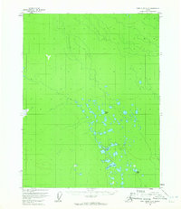
1956 · Fort Yukon D-6
USGS Topo · 1:63,360

1964 · Chandalar
USGS Topo · 1:250,000