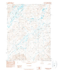
1990 Map of Chandalar B-2
USGS Topo · Published 1990About this map
The Middle Fork Chandalar River and the main stem of the Chandalar River converge in this northern Alaskan landscape, where the terrain is marked by high summits like Ackerman and Funchion. A seasonal Winter Trail provides a critical transport corridor through the river valley, reflecting the area's dependence on temporary routes for navigation across the wetlands and tundra. Evidence of human presence is sparse but distinct, centered on the Simplex site and scattered Cabin locations that likely served trappers, hunters, or explorers. The alignment of the Fairbanks Meridian passes through the eastern portion of the map, anchoring this remote interior wilderness within the larger Alaskan survey system. This map captures a specific moment when wilderness infrastructure was limited to these few named camps and drainage-following trails like those along Flat Creek.
Find a feature on this map
9 named features on this map. Tap any name to fly to it.
Don’t see what you’re looking for? This feature index may not catch every label — zoom into the map to look around manually.
Map Details
Editions of this 1990 Chandalar B-2 Map
This is the sole edition of this map. No revisions or reprints were ever made.
Other maps of this area

1951 · Chandalar
USGS Topo · 1:250,000

1956 · Chandalar
USGS Topo · 1:250,000

1964 · Chandalar
USGS Topo · 1:250,000
1990 · Chandalar A-2
USGS Topo · 1:63,360
1990 · Chandalar A-1
USGS Topo · 1:63,360
1990 · Chandalar B-3
USGS Topo · 1:63,360

1990 · Chandalar C-2
USGS Topo · 1:63,360
1990 · Chandalar B-1
USGS Topo · 1:63,360
1990 · Chandalar A-3
USGS Topo · 1:63,360
1990 · Chandalar C-1
USGS Topo · 1:63,360