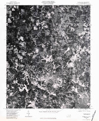
1980 Map of Chapel Hill
USGS Topo · Published 1983About this map
Chapel Hill and its surrounding Orange County landscape are revealed in sharp detail through this 1980 orthophotomap, which utilizes rectified aerial imagery to document the community's physical footprint. The town center and university areas appear as a dense concentration of structures and roadways, contrasted by the wooded drainages and cleared agricultural parcels to the north and west. To the south, University Lake stands as a prominent geographic anchor, while the small settlement of Eubanks marks the northern rural reaches. The meandering course of New Hope Creek cuts through the northeastern terrain, illustrating the natural watershed that influenced the region's development. This photographic perspective provides researchers with a precise visual record of land use, forest cover, and residential expansion during a period of significant growth for the university town.
Find a feature on this map
4 named features on this map. Tap any name to fly to it.
Don’t see what you’re looking for? This feature index may not catch every label — zoom into the map to look around manually.
Map Details
Editions of this 1980 Chapel Hill Map
This is the sole edition of this map. No revisions or reprints were ever made.
Other maps of this area

1943 · Durham South
USGS Topo · 1:62,500

1946 · Chapel Hill
USGS Topo · 1:24,000

1947 · Chapel Hill
USGS Topo · 1:31,680

1951 · Farrington
USGS Topo · 1:24,000

1951 · Durham South
USGS Topo · 1:62,500

1951 · Durham North
USGS Topo · 1:62,500

1953 · Raleigh
USGS Topo · 1:250,000

1953 · Greensboro
USGS Topo · 1:250,000

1954 · Greensboro
USGS Topo · 1:250,000

1954 · Raleigh
USGS Topo · 1:250,000