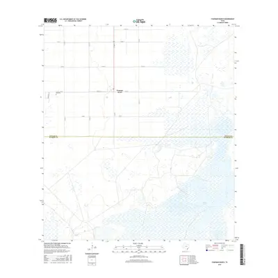
2016 Map of Chapman Ranch
USGS Topo · Published 2016About this map
Chapman Ranch serves as the central hub of this coastal Texas agricultural landscape, situated just north of the Nueces Co Kleberg Co line. The map captures a meticulously gridded system of rural roads, including Co Rd 14 and Co Rd 45, which organize the vast fields of this historic ranching and farming district. Local history is anchored by the Chapman Ranch Cem located along Fm 70, and the presence of a Po marks the settlement's role as a community center. To the southeast, the terrain shifts into the wetlands and marshes surrounding Laguna Larga, illustrating the transition from managed cropland to the natural hydrology of the Texas coastal bend. This 2016 survey documents the enduring infrastructure of the ranch, from its named lanes like Santa Cruz Ln to the essential drainage provided by the central Stream.
Find a feature on this map
17 named features on this map. Tap any name to fly to it.
Don’t see what you’re looking for? This feature index may not catch every label — zoom into the map to look around manually.
Map Details
Editions of this 2016 Chapman Ranch Map
This is the sole edition of this map. No revisions or reprints were ever made.
Other maps of this area
1924 · Petronilla
USGS Topo · 1:62,500
1925 · Oso Creek
USGS Topo · 1:62,500
1928 · Sarita
USGS Topo · 1:125,000
1950 · Corpus Christi
USGS Topo · 1:250,000
1951 · South Bird Island
USGS Topo · 1:24,000
1951 · South Bird Island NW
USGS Topo · 1:24,000
1951 · Oso Creek NW
USGS Topo · 1:24,000
1951 · Oso Creek NE
USGS Topo · 1:24,000
1951 · Riviera Beach NE
USGS Topo · 1:24,000
1951 · Oso Creek
USGS Topo · 1:62,500