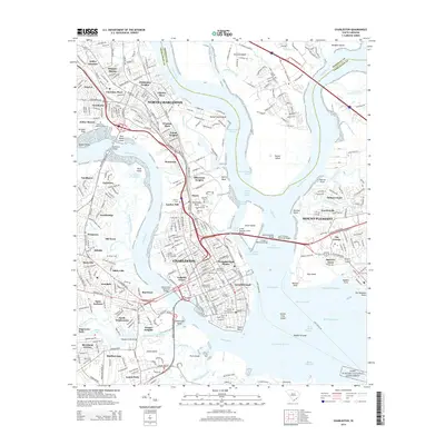
2014 Map of Charleston
USGS Topo · Published 2014About this map
Charleston and North Charleston define this coastal landscape, situated where the Ashley River and Cooper River converge into the harbor. The map documents the dense urban grid of the historic peninsula, featuring long-established institutions like the Citadel Military Coll of S Carolina and the Coll of Charleston. To the north, industrial reaches such as Navy Yard Reach and Shipyard Cr underscore the region's maritime and military legacy. The landscape is a mosaic of historic neighborhoods and burial grounds, including the large Magnolia Cem and Saint Lawrence Cem complexes along the Neck. Modern infrastructure is prominent, particularly the Arthur Ravenel Junior Bridge connecting to Mount Pleasant, while the Fort Sumter National Monument stands at the harbor's mouth, anchoring the area's deep naval history.
Find a feature on this map
125 named features on this map. Tap any name to fly to it.
Don’t see what you’re looking for? This feature index may not catch every label — zoom into the map to look around manually.
Map Details
Editions of this 2014 Charleston Map
This is the sole edition of this map. No revisions or reprints were ever made.
Other maps of this area

1919 · Ladson
USGS Topo · 1:21,120

1919 · Johns Island
USGS Topo · 1:21,120

1919 · The Jetties
USGS Topo · 1:21,120

1919 · Wadmelaw Island
USGS Topo · 1:62,500

1919 · Wando
USGS Topo · 1:21,120

1919 · Melgrove
USGS Topo · 1:21,120

1919 · Charleston
USGS Topo · 1:21,120

1919 · James Island
USGS Topo · 1:21,120

1919 · Fort Moultrie
USGS Topo · 1:21,120

1919 · Legareville
USGS Topo · 1:21,120
Featured Places
- Charleston, SC
- North Charleston, SC
- Mount Pleasant, SC
- Murray Landing, SC
- Daniel Jenkins Homes, North Charleston