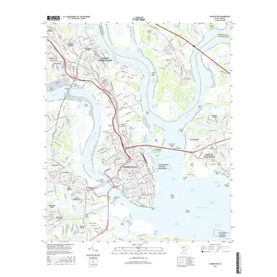
2017 Map of Charleston
USGS Topo · Published 2017About this map
The Cooper River and Ashley River converge at the historic tip of the peninsula to form Charleston Harbor, a landscape defined by its maritime reaches and complex waterway network. This 2017 survey details the dense urban core of Charleston, featuring institutions like the Coll of Charleston and Medical Univ of SC. Beyond the main city, the map traces the suburban and industrial growth of North Charleston and Mount Pleasant, connected by the massive Arthur Ravenel Junior Bridge. Cultural and genealogical history is preserved in the cluster of burial grounds including Magnolia Cem, Saint Lawrence Cem, and the Hebrew Cem. In the harbor, Fort Sumter National Monument stands as a sentinel near Patriots Point, while the surrounding marshlands and reaches like Rebellion Reach and Hog Island Reach illustrate the intricate tidal geography of the South Carolina Lowcountry.
Find a feature on this map
377 named features on this map. Tap any name to fly to it.
Don’t see what you’re looking for? This feature index may not catch every label — zoom into the map to look around manually.
Map Details
Editions of this 2017 Charleston Map
This is the sole edition of this map. No revisions or reprints were ever made.
Other maps of this area

1919 · Ladson
USGS Topo · 1:21,120

1919 · Johns Island
USGS Topo · 1:21,120

1919 · The Jetties
USGS Topo · 1:21,120

1919 · Wadmelaw Island
USGS Topo · 1:62,500

1919 · Wando
USGS Topo · 1:21,120

1919 · Melgrove
USGS Topo · 1:21,120

1919 · Charleston
USGS Topo · 1:21,120

1919 · James Island
USGS Topo · 1:21,120

1919 · Fort Moultrie
USGS Topo · 1:21,120

1919 · Legareville
USGS Topo · 1:21,120
Featured Places
- Charleston, SC
- North Charleston, SC
- Mount Pleasant, SC
- Murray Landing, SC
- Daniel Jenkins Homes, North Charleston