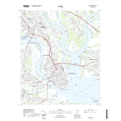
2020 Map of Charleston
USGS Topo · Published 2020About this map
Charleston and its surrounding harbor islands are shown here in the 2020s, revealing the dense urban fabric of the peninsula and the modern infrastructure connecting it to Mount Pleasant and North Charleston. The map meticulously details the educational and historical core of the city, from The Citadel Military College of South Carolina to the College of Charleston. Along the waterfront, Oyster Point and Patriots Point anchor the harbor, while the Arthur Ravenel Junior Bridge spans the Cooper River to the east. Extensive marshlands and complex waterways, including the Intracoastal Waterway and Wappoo Creek, define the city's relationship with the Atlantic. Deep-rooted history is visible in sites like the Quaker Churchyard and the sprawl of Magnolia Cem to the north, providing a clear record of the region's long-standing cultural and maritime identity.
Find a feature on this map
93 named features on this map. Tap any name to fly to it.
Don’t see what you’re looking for? This feature index may not catch every label — zoom into the map to look around manually.
Map Details
Editions of this 2020 Charleston Map
This is the sole edition of this map. No revisions or reprints were ever made.
Other maps of this area

1919 · Ladson
USGS Topo · 1:21,120

1919 · Johns Island
USGS Topo · 1:21,120

1919 · The Jetties
USGS Topo · 1:21,120

1919 · Wadmelaw Island
USGS Topo · 1:62,500

1919 · Wando
USGS Topo · 1:21,120

1919 · Melgrove
USGS Topo · 1:21,120

1919 · Charleston
USGS Topo · 1:21,120

1919 · James Island
USGS Topo · 1:21,120

1919 · Fort Moultrie
USGS Topo · 1:21,120

1919 · Legareville
USGS Topo · 1:21,120
Featured Places
- Charleston, SC
- North Charleston, SC
- Mount Pleasant, SC
- Murray Landing, SC
- Daniel Jenkins Homes, North Charleston