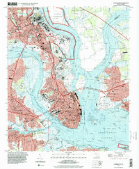
1994 Map of Charleston
USGS Topo · Published 2000About this map
The historic peninsula of Charleston is captured here as it appeared in the mid-1990s, anchored by the dense street grid between the Ashley River and Cooper River. The map details the city's significant maritime and military presence, from the expansive US Naval Reservation and its drydocks in the north to the Customhouse and White Point Gardens at the Battery. Across the water, the USS Yorktown State Park at Patriots Point and the remote Fort Sumter Natl Mon in the mouth of the Charleston Harbor mark key points of coastal defense and heritage.
Find a feature on this map
103 named features on this map. Tap any name to fly to it.
Don’t see what you’re looking for? This feature index may not catch every label — zoom into the map to look around manually.
Map Details
Editions of this 1994 Charleston Map
This is the sole edition of this map. No revisions or reprints were ever made.
Other maps of this area

1919 · Ladson
USGS Topo · 1:21,120

1919 · Johns Island
USGS Topo · 1:21,120

1919 · The Jetties
USGS Topo · 1:21,120

1919 · Wadmelaw Island
USGS Topo · 1:62,500

1919 · Wando
USGS Topo · 1:21,120

1919 · Melgrove
USGS Topo · 1:21,120

1919 · Charleston
USGS Topo · 1:21,120

1919 · James Island
USGS Topo · 1:21,120

1919 · Fort Moultrie
USGS Topo · 1:21,120

1919 · Legareville
USGS Topo · 1:21,120
Featured Places
- Charleston, SC
- North Charleston, SC
- Mount Pleasant, SC
- Ashley Junction, North Charleston
- Daniel Jenkins Homes, North Charleston