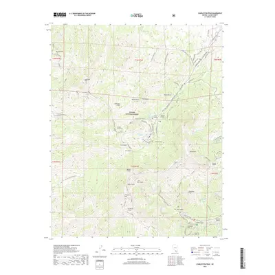
2018 Map of Charleston Peak
USGS Topo · Published 2018About this map
Charleston Peak dominates this high-altitude landscape within the Toiyabe National Forest, marking a dramatic vertical environment in the Spring Mountains. The 2018 survey reveals a specialized network of recreation and mountain infrastructure, concentrated around the steep drainage of Lee Canyon and Kyle Canyon. A complex system of trails and service roads, such as the Bristlecone and Sawmill Loop, navigates the sharp terrain between peaks. Water sources are scarce but critical, appearing as isolated features like McWilliams Spring and the seasonal Mary Jane Falls. The map documents the localized development of the Lee Ski Area Rd and various forest roads like Tennella Road, illustrating how the region is managed for both preservation and seasonal tourism. Notable landmarks like Mummy Mtn and Cathedral Rock provide distinct navigational anchors for those studying the area's geology and wilderness history.
Find a feature on this map
76 named features on this map. Tap any name to fly to it.
Don’t see what you’re looking for? This feature index may not catch every label — zoom into the map to look around manually.
Map Details
Editions of this 2018 Charleston Peak Map
This is the sole edition of this map. No revisions or reprints were ever made.
Other maps of this area

1907 · Las Vegas
USGS Topo · 1:250,000

1908 · Las Vegas
USGS Topo · 1:250,000

1954 · Las Vegas
USGS Topo · 1:250,000

1957 · Las Vegas
USGS Topo · 1:250,000

1957 · Mt. Stirling
USGS Topo · 1:62,500

1957 · Charleston Peak
USGS Topo · 1:62,500

1957 · Mountain Springs
USGS Topo · 1:62,500
1958 · Pahrump
USGS Topo · 1:62,500

1959 · Las Vegas
USGS Topo · 1:250,000

1962 · Las Vegas
USGS Topo · 1:250,000