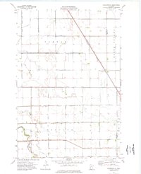
1974 Map of Charlesville
USGS Topo · Published 1976About this map
Charlesville sits at the intersection of local township boundaries and the Burlington Northern railroad, serving as a focal point in this intensely managed agricultural landscape of the 1970s. The map illustrates a highly engineered hydrologic system designed to drain the fertile plains of Tintah, Redpath, and North Ottawa. This network is defined by an extensive grid of drainage projects, including Judicial Ditch No 12 and County Ditch No 11, which redirect water toward the southern watercourses. In the southern portion of the quadrangle, the natural meandering of the Mustinka River and Fivemile Creek contrasts with the straight lines of the man-made channels. The presence of the Old Channel indicates a legacy of stream diversion and modification, typical of the Red River Valley's agricultural development as farmers sought to manage seasonal flooding and maximize arable land.
Find a feature on this map
20 named features on this map. Tap any name to fly to it.
Don’t see what you’re looking for? This feature index may not catch every label — zoom into the map to look around manually.
Map Details
Editions of this 1974 Charlesville Map
This is the sole edition of this map. No revisions or reprints were ever made.
Other maps of this area

1910 · Wendell
USGS Topo · 1:62,500

1911 · Herman
USGS Topo · 1:62,500

1913 · Wendell
USGS Topo · 1:62,500

1951 · Wheaton
USGS Topo · 1:62,500

1951 · Campbell
USGS Topo · 1:62,500

1953 · Milbank
USGS Topo · 1:250,000

1953 · Fargo
USGS Topo · 1:250,000

1956 · Fargo
USGS Topo · 1:250,000

1958 · Milbank
USGS Topo · 1:250,000

1973 · Herman NW
USGS Topo · 1:24,000