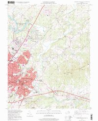
1997 Map of Charlottesville East
USGS Topo · Published 1999About this map
The Rivanna River serves as the central artery for this Virginia landscape, where the urban expansion of Charlottesville meets the rolling foothills of the Southwest Mountains. Significant historical sites are concentrated along the southern ridges, most notably the Jefferson Tomb and the nearby Michie Tavern situated on Carters Mountain. The map illustrates the confluence where the North Fork Rivanna River joins the main stem near Key West, a point where the terrain shifts from the developed corridors of Hydraulic Road to more open farmland and forest.
Find a feature on this map
81 named features on this map. Tap any name to fly to it.
Don’t see what you’re looking for? This feature index may not catch every label — zoom into the map to look around manually.
Map Details
Editions of this 1997 Charlottesville East Map
This is the sole edition of this map. No revisions or reprints were ever made.
Other maps of this area

1891 · Palmyra
USGS Topo · 1:125,000

1892 · Buckingham
USGS Topo · 1:125,000

1892 · Gordonsville
USGS Topo · 1:125,000

1892 · Harrisonburg
USGS Topo · 1:125,000

1895 · Palmyra
USGS Topo · 1:125,000

1897 · Palmyra
USGS Topo · 1:125,000

1929 · Covesville
USGS Topo · 1:62,500

1931 · University
USGS Topo · 1:62,500

1935 · Charlottesville
USGS Topo · 1:62,500

1935 · Charlottesville And Vicinity
USGS Topo · 1:31,680