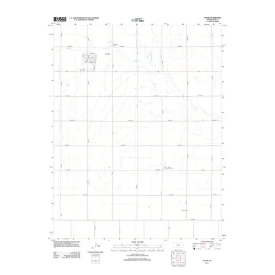
2012 Map of Chase
USGS Topo · Published 2012About this map
The town of Chase sits at the center of this agricultural landscape in Rice County, defined by a strict section-line road grid and the meandering paths of Spring Cr and Cow Cr. This 2012 survey illustrates the town's compact residential core, with streets like Main St and Tyrrell Rd anchoring the community near the local Po. Outside the immediate settlement, the landscape transitions into a center of energy production, dominated by the Tobias Oil Field and the Tobias Northwest Oil Field. Genealogists will find the locations of Springdale Cem to the north and Saint Mary's Cem to the south, both of which serve as enduring landmarks for family histories in this rural Kansas prairie region.
Find a feature on this map
28 named features on this map. Tap any name to fly to it.
Don’t see what you’re looking for? This feature index may not catch every label — zoom into the map to look around manually.
Map Details
Editions of this 2012 Chase Map
This is the sole edition of this map. No revisions or reprints were ever made.
Other maps of this area

1894 · Lyons
USGS Topo · 1:125,000

1955 · Great Bend
USGS Topo · 1:250,000

1957 · Great Bend
USGS Topo · 1:250,000

1958 · Great Bend
USGS Topo · 1:250,000

1967 · Alden
USGS Topo · 1:24,000

1967 · Alden NW
USGS Topo · 1:24,000
1967 · Sterling
USGS Topo · 1:24,000

1970 · Lyons
USGS Topo · 1:24,000
1970 · Chase NE
USGS Topo · 1:24,000
1970 · Raymond
USGS Topo · 1:24,000