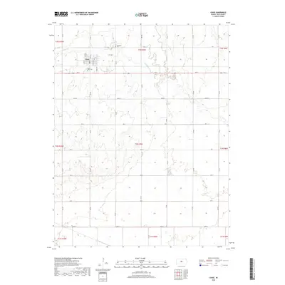
2018 Map of Chase
USGS Topo · Published 2018About this map
Chase serves as the central hub of this Rice County landscape, its grid defined by Main St and Elm St just north of Ave M. The surrounding plains are marked by a regular pattern of section roads and drainage systems, with Spring Cr and Cow Cr carving subtle paths through the terrain. Local history and genealogy are anchored by two significant sites: Springdale Cem to the north and Saint Mary's Cem situated just south of the town center. This area reflects the enduring agricultural layout of central Kansas, where the township and range system dictates the placement of nearly every road and property boundary, such as Tyrrell Rd and 10th Rd.
Find a feature on this map
35 named features on this map. Tap any name to fly to it.
Don’t see what you’re looking for? This feature index may not catch every label — zoom into the map to look around manually.
Map Details
Editions of this 2018 Chase Map
This is the sole edition of this map. No revisions or reprints were ever made.
Other maps of this area
1894 · Lyons
USGS Topo · 1:125,000

1955 · Great Bend
USGS Topo · 1:250,000

1957 · Great Bend
USGS Topo · 1:250,000

1958 · Great Bend
USGS Topo · 1:250,000
1967 · Alden
USGS Topo · 1:24,000
1967 · Alden NW
USGS Topo · 1:24,000
1967 · Sterling
USGS Topo · 1:24,000
1970 · Lyons
USGS Topo · 1:24,000
1970 · Chase NE
USGS Topo · 1:24,000
1970 · Raymond
USGS Topo · 1:24,000