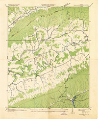
1934 Map of Chatham Hill
USGS Topo · Published 1934About this map
Chatham Hill and the surrounding valley floor are defined by the meandering course of the North Fork Holston River, as seen in this 1934 field examination. The landscape is structured by prominent ridges including Brushy Mountain and Rich Mountain, which separate the agricultural lowlands from more secluded areas like Poor Valley. Rural life is anchored by a network of one-room schools such as New Cove Sch and Old Cove Sch, alongside community landmarks like Crabtree Chapel and Goodman Chapel. A significant moment in local geography is captured in the south, where the map identifies the Proposed Hungry Mother Lake within Hungry Mother State Park, marking the transition of the terrain into a managed recreation area. Small clusters of homes at Tannersville and Ridgedale illustrate the early 20th-century settlement patterns of Smyth County before modern expansion.
Find a feature on this map
47 named features on this map. Tap any name to fly to it.
Don’t see what you’re looking for? This feature index may not catch every label — zoom into the map to look around manually.
Map Details
Editions of this 1934 Chatham Hill Map
This is the sole edition of this map. No revisions or reprints were ever made.
Other maps of this area

1887 · Pocahontas
USGS Topo · 1:125,000

1889 · Wytheville
USGS Topo · 1:125,000

1891 · Tazewell
USGS Topo · 1:125,000

1891 · Pocahontas
USGS Topo · 1:125,000

1891 · Abingdon
USGS Topo · 1:125,000

1892 · Wytheville
USGS Topo · 1:125,000

1894 · Pocahontas
USGS Topo · 1:125,000

1894 · Abingdon
USGS Topo · 1:125,000

1895 · Tazewell
USGS Topo · 1:125,000

1895 · Pocahontas
USGS Topo · 1:125,000