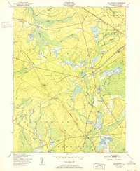
1951 Map of Chatsworth
USGS Topo · Published 1951About this map
The Lebanon State Forest and the expansive Chatsworth Woods define this mid-century landscape in Burlington County. The Central Railroad of New Jersey cuts a diagonal path through the terrain, connecting the settlement of Chatsworth with Harris Station. This era shows a specialized local economy centered on water management and resource extraction, evidenced by numerous Cranberry Bogs along the West Branch Wading River and the presence of the Zing Ore Refinery.
Find a feature on this map
48 named features on this map. Tap any name to fly to it.
Don’t see what you’re looking for? This feature index may not catch every label — zoom into the map to look around manually.
Map Details
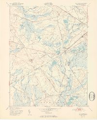
Editions of this 1951 Chatsworth Map
2 editions found
Other maps of this area

1884 · Whitings
USGS Topo · 1:62,500

1888 · Pemberton
USGS Topo · 1:62,500

1888 · Little Egg Harbor
USGS Topo · 1:62,500

1888 · Whitings
USGS Topo · 1:62,500

1890 · Mullica
USGS Topo · 1:62,500

1893 · Little Egg Harbor
USGS Topo · 1:62,500

1894 · Pemberton
USGS Topo · 1:62,500

1894 · Mullica
USGS Topo · 1:62,500

1898 · Pemberton
USGS Topo · 1:62,500

1898 · Mullica
USGS Topo · 1:62,500
Featured Places
- Tabernacle Township, NJ
- Washington Township, NJ
- Johnson Place, Woodland Township
- Butlers Place, Woodland Township
- Chatsworth, Woodland Township