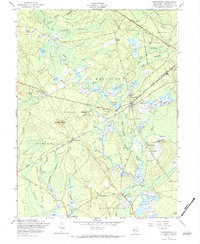
1957 Map of Chatsworth
USGS Topo · Published 1984About this map
The Central RR of New Jersey cuts a diagonal line through this 1957 landscape, anchoring the settlement of Chatsworth and its local landmarks like the Chatsworth Cem and Chatsworth Lake. This area of Burlington County is defined by an extensive network of waterways and wetlands, including numerous cranberry bogs situated along the West Branch Wading River and Pole Bridge Branch. The map reveals the working character of the Pine Barrens during the mid-20th century, where isolated outposts like Pine Crest, Whitehorse, and Johnson Place are linked by sandy tracks and unimproved roads.
Find a feature on this map
39 named features on this map. Tap any name to fly to it.
Don’t see what you’re looking for? This feature index may not catch every label — zoom into the map to look around manually.
Map Details
Editions of this 1957 Chatsworth Map
4 editions found
Other maps of this area

1884 · Whitings
USGS Topo · 1:62,500

1888 · Pemberton
USGS Topo · 1:62,500

1888 · Little Egg Harbor
USGS Topo · 1:62,500

1888 · Whitings
USGS Topo · 1:62,500

1890 · Mullica
USGS Topo · 1:62,500

1893 · Little Egg Harbor
USGS Topo · 1:62,500

1894 · Pemberton
USGS Topo · 1:62,500

1894 · Mullica
USGS Topo · 1:62,500

1898 · Pemberton
USGS Topo · 1:62,500

1898 · Mullica
USGS Topo · 1:62,500