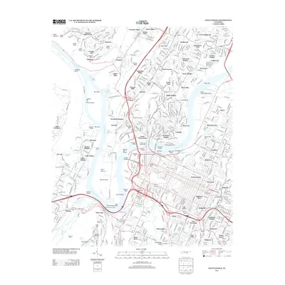
2013 Map of Chattanooga
USGS Topo · Published 2013About this map
Moccasin Bend dominates the riverine landscape where the Tennessee River makes its dramatic hairpin turn, overlooked by the prominent heights of Lookout Mountain. This 2013 survey details the modern urban core and its industrial infrastructure, featuring large rail operations at Cravens Yards and the Shipps Yards. The map documents the historic gateway to the city, from the Chief John Ross Bridge spanning the river to the Missionary Ridge Tunnel to the east. Cultural landmarks like the Tennessee Aquarium and the Old Stone Church Tower stand alongside historical sites such as Point Park and the Cravens House. The surrounding residential development is marked by a complex of neighborhoods including North Chattanooga, Lupton City, and Stuart Heights, while the river's navigational history is preserved in labels for Browns Ferry and various shoals and bars that once challenged river pilots.
Find a feature on this map
119 named features on this map. Tap any name to fly to it.
Don’t see what you’re looking for? This feature index may not catch every label — zoom into the map to look around manually.
Map Details
Editions of this 2013 Chattanooga Map
This is the sole edition of this map. No revisions or reprints were ever made.
Other maps of this area

1886 · Ringgold
USGS Topo · 1:125,000

1888 · Chattanooga
USGS Topo · 1:125,000

1892 · Ringgold
USGS Topo · 1:125,000

1893 · Chattanooga
USGS Topo · 1:125,000

1935 · East Chattanooga
USGS Topo · 1:24,000

1935 · Daisy
USGS Topo · 1:24,000

1935 · East Ridge
USGS Topo · 1:24,000

1936 · Ketner Gap
USGS Topo · 1:24,000

1936 · Hooker
USGS Topo · 1:24,000

1936 · Fort Oglethorpe
USGS Topo · 1:24,000