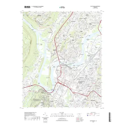
2019 Map of Chattanooga
USGS Topo · Published 2019About this map
Moccasin Bend anchors a dramatic loop of the Tennessee River as it passes through the heart of this urban and industrial landscape. The map highlights the city's complex layering of history, from the preserved Civil War grounds of Chickamauga and Chattanooga National Military Park to the solemn rows of the Chattanooga National Cemetery. The urban core is connected by monumental spans like the Walnut Street Bridge and the Chief John Ross Bridge, while the residential character of neighborhoods like North Chattanooga, Red Bank, and Stuart Heights is clearly defined. Along the eastern edge, Missionary Ridge rises above the city, pierced by the Missionary Ridge Tunnel, a vital transportation link. Cultural and natural landmarks such as Ruby Falls on Lookout Mountain and the Mizpah Congregation Cem reflect the city's diverse heritage and the geological prominence of the Cumberland Escarpment.
Find a feature on this map
130 named features on this map. Tap any name to fly to it.
Don’t see what you’re looking for? This feature index may not catch every label — zoom into the map to look around manually.
Map Details
Editions of this 2019 Chattanooga Map
This is the sole edition of this map. No revisions or reprints were ever made.
Other maps of this area

1886 · Ringgold
USGS Topo · 1:125,000

1888 · Chattanooga
USGS Topo · 1:125,000

1892 · Ringgold
USGS Topo · 1:125,000

1893 · Chattanooga
USGS Topo · 1:125,000

1935 · East Chattanooga
USGS Topo · 1:24,000

1935 · Daisy
USGS Topo · 1:24,000

1935 · East Ridge
USGS Topo · 1:24,000

1936 · Ketner Gap
USGS Topo · 1:24,000

1936 · Hooker
USGS Topo · 1:24,000

1936 · Fort Oglethorpe
USGS Topo · 1:24,000