
1957 Map of Chattanooga
USGS Topo · Published 1966About this map
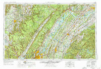
Chattanooga serves as the industrial and transportation hub for this mid-century survey of East Tennessee, situated at the dramatic bend of the Tennessee River. The landscape is dominated by the massive Cumberland Plateau and the sharp incline of Walden Ridge, which partition the region into distinct river valleys and highland forests. The era’s industrial footprint is significant, featuring the Atomic Energy Commission (Oak Ridge Area) at the northeast corner and the Volunteer Army Ammunition Plant near the city center.
Find a feature on this map
120 named features on this map. Tap any name to fly to it.
Don’t see what you’re looking for? This feature index may not catch every label — zoom into the map to look around manually.
Map Details
Editions of this 1957 Chattanooga Map
3 editions found
Other maps of this area

1886 · Dalton
USGS Topo · 1:125,000

1886 · Cleveland
USGS Topo · 1:125,000

1886 · Knoxville
USGS Topo · 1:125,000

1886 · Ringgold
USGS Topo · 1:125,000

1886 · Stevenson
USGS Topo · 1:125,000

1886 · Dahlonega
USGS Topo · 1:125,000

1887 · Kingston
USGS Topo · 1:125,000

1888 · Ellijay
USGS Topo · 1:125,000

1888 · Chattanooga
USGS Topo · 1:125,000

1888 · Scottsboro
USGS Topo · 1:125,000