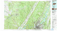
1988 Map of Chattanooga
USGS Topo · Published 1991About this map
The Sequatchie Valley cuts a dramatic diagonal across the heart of this regional study, separating the industrial and urban center of Chattanooga from the high, coal-bearing tablelands of the Cumberland Plateau. The landscape is a study in 1980s infrastructure and natural resource extraction, showing the extensive Strip Mines on the plateau near Palmer and Coalmont, alongside the massive hydroelectric and navigational impoundments of Chickamauga Lake and Nickajack Lake on the Tennessee River.
Find a feature on this map
78 named features on this map. Tap any name to fly to it.
Don’t see what you’re looking for? This feature index may not catch every label — zoom into the map to look around manually.
Map Details
Editions of this 1988 Chattanooga Map
This is the sole edition of this map. No revisions or reprints were ever made.
Other maps of this area

1886 · Dalton
USGS Topo · 1:125,000

1886 · Cleveland
USGS Topo · 1:125,000

1886 · Ringgold
USGS Topo · 1:125,000

1886 · Stevenson
USGS Topo · 1:125,000

1887 · Kingston
USGS Topo · 1:125,000

1888 · Chattanooga
USGS Topo · 1:125,000

1888 · Scottsboro
USGS Topo · 1:125,000

1891 · Kingston
USGS Topo · 1:125,000

1892 · Pikeville
USGS Topo · 1:125,000

1892 · Ringgold
USGS Topo · 1:125,000