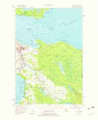
1957 Map of Cheboygan
USGS Topo · Published 1982About this map
The industrial and maritime hub of Cheboygan sits at the confluence of the Cheboygan River and the South Channel, serving as a gateway to the Straits of Mackinac in the late 1950s. This survey reveals a landscape where rail lines like the New York Central and the Detroit and Mackinac converge at the port, supporting local operations like the city Waterworks. Away from the urban center, the map details the rugged interior of the Mackinaw State Forest and the early recreational developments around Mullett Lake, including Aloha State Park. Genealogists will find significant value in the detailed plotting of rural landmarks, such as Calvary Cem, St Francis Cem, and several numbered schoolhouses like School No 2 and School No 7, which once anchored now-vanished rural communities across Benton and Aloha townships.
Find a feature on this map
70 named features on this map. Tap any name to fly to it.
Don’t see what you’re looking for? This feature index may not catch every label — zoom into the map to look around manually.
Map Details
Editions of this 1957 Cheboygan Map
3 editions found
Other maps of this area

1955 · Cheboygan
USGS Topo · 1:250,000

1957 · Tower
USGS Topo · 1:62,500

1957 · Wolverine
USGS Topo · 1:62,500

1957 · Cheboygan
USGS Topo · 1:62,500

1957 · Mullett Lake
USGS Topo · 1:62,500

1957 · Onaway
USGS Topo · 1:62,500

1958 · Cheboygan
USGS Topo · 1:250,000

1958 · Grace
USGS Topo · 1:62,500

1964 · Round Island
USGS Topo · 1:24,000

1964 · McRae Bay
USGS Topo · 1:24,000