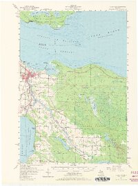
1957 Map of Cheboygan
USGS Topo · Published 1971About this map
The Cheboygan River serves as the primary artery for this lakeside region, flowing through the heart of Cheboygan into the South Channel. In the mid-1950s, the landscape was defined by its timber heritage and emerging recreation, with the Black Lake State Forest and Aloha State Park providing significant public acreage. Industrial and community footprints are visible in the Tannery and a Drive-in Theater south of town, while the New York Central and Detroit and Mackinac railroads provided critical transit links to the interior.
Find a feature on this map
73 named features on this map. Tap any name to fly to it.
Don’t see what you’re looking for? This feature index may not catch every label — zoom into the map to look around manually.
Map Details
Editions of this 1957 Cheboygan Map
3 editions found
Other maps of this area

1955 · Cheboygan
USGS Topo · 1:250,000

1957 · Tower
USGS Topo · 1:62,500

1957 · Wolverine
USGS Topo · 1:62,500

1957 · Cheboygan
USGS Topo · 1:62,500

1957 · Mullett Lake
USGS Topo · 1:62,500

1957 · Onaway
USGS Topo · 1:62,500

1958 · Cheboygan
USGS Topo · 1:250,000

1958 · Grace
USGS Topo · 1:62,500

1964 · Round Island
USGS Topo · 1:24,000

1964 · McRae Bay
USGS Topo · 1:24,000