
1958 Map of Grace
USGS Topo · Published 1959About this map
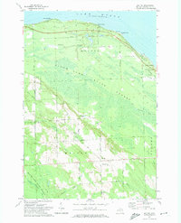
Lake Huron and the sweeping shoreline of Hammond Bay dominate this 1958 survey of the northern Presque Isle coast. The landscape is characterized by dense woodlands and interior waterways, including Black Mallard Lake, Clear Lake, and Mud Lake, many of which are contained within the Black Lake State Forest. Settlement is sparse, focused around the small community of Greene and the coastal vicinity of Grace Cem. Evidence of local infrastructure and early structures appear along the lakeshore, notably the Huron Beach Ch and unidentified Ruins near the bay. The map provides a detailed view of the natural topography before significant modern development, showing the winding course of Mulligan Creek and prominent coastal landmarks like Ninemile Point and Mast Point which have long served as navigations aids for the region's maritime activity.
Find a feature on this map
19 named features on this map. Tap any name to fly to it.
Don’t see what you’re looking for? This feature index may not catch every label — zoom into the map to look around manually.
Map Details
Editions of this 1958 Grace Map
This is the sole edition of this map. No revisions or reprints were ever made.
Other maps of this area

1954 · Alpena
USGS Topo · 1:250,000

1955 · Cheboygan
USGS Topo · 1:250,000

1957 · Alpena
USGS Topo · 1:250,000

1957 · Tower
USGS Topo · 1:62,500

1957 · Cheboygan
USGS Topo · 1:62,500

1957 · Onaway
USGS Topo · 1:62,500

1958 · Cheboygan
USGS Topo · 1:250,000

1958 · Alpena
USGS Topo · 1:250,000

1969 · Alpena
USGS Topo · 1:250,000
1971 · Moltke
USGS Topo · 1:24,000