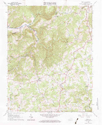
1963 Map of Check
USGS Topo · Published 1984About this map
The Blue Ridge Parkway defines the high southeastern ridge of this landscape, winding through the complex meeting point of Floyd, Roanoke, and Franklin counties. This 1963 survey captures the rural character of the Blue Ridge Highlands, where small community hubs like Check and Simpsons are connected by a network of drainage-following roads. The headwaters of the South Fork Roanoke River and the Little River carve deep valleys through the upland, creating the high-relief terrain of Lick Ridge. Local history is preserved in several family and community landmarks, from the Salem Cem and Simpson Cem to rural congregations at Pine Forest Ch and St Pauls Ch. Of particular note is the Mid-Century recreational and social footprint, evidenced by Camp Kiwanianna in the north and a Drive-in Theater located centrally near the highway junction.
Find a feature on this map
41 named features on this map. Tap any name to fly to it.
Don’t see what you’re looking for? This feature index may not catch every label — zoom into the map to look around manually.
Map Details
Editions of this 1963 Check Map
3 editions found
Other maps of this area

1890 · Christiansburg
USGS Topo · 1:125,000

1932 · Blacksburg
USGS Topo · 1:48,000

1937 · Blacksburg
USGS Topo · 1:62,500

1950 · Elliston
USGS Topo · 1:62,500

1953 · Winston-Salem
USGS Topo · 1:250,000

1955 · Bluefield
USGS Topo · 1:250,000

1955 · Winston-Salem
USGS Topo · 1:250,000

1957 · Endicott
USGS Topo · 1:62,500

1957 · Floyd
USGS Topo · 1:62,500

1957 · Bluefield
USGS Topo · 1:250,000