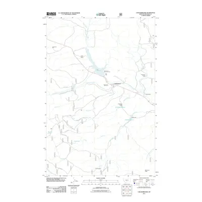
2011 Map of Checkerboard
USGS Topo · Published 2011About this map
The settlement of Checkerboard sits at the confluence of several high-country water systems, anchored by the North Fork Musselshell River and Checkerboard Creek. This 2011 survey details a landscape where industrial history meets modern water management, notably at the Copperopolis Mine and the SW SW Section 27 Mine in the northwest. The terrain is defined by significant ridges like Fries Ridge and Whetstone Ridge, which separate a series of creek drainages including Stohr Creek and Flagstaff Creek.
Find a feature on this map
37 named features on this map. Tap any name to fly to it.
Don’t see what you’re looking for? This feature index may not catch every label — zoom into the map to look around manually.
Map Details
Editions of this 2011 Checkerboard Map
This is the sole edition of this map. No revisions or reprints were ever made.
Other maps of this area

1886 · Little Belt Mts.
USGS Topo · 1:250,000

1894 · Little Belt Mts.
USGS Topo · 1:250,000

1897 · Little Belt Mts.
USGS Topo · 1:250,000

1898 · Little Belt Mts.
USGS Topo · 1:250,000

1902 · Little Belt Mts.
USGS Topo · 1:250,000

1948 · White Sulphur Springs
USGS Topo · 1:250,000

1958 · White Sulphur Springs
USGS Topo · 1:250,000

1961 · White Sulphur Springs
USGS Topo · 1:250,000

1965 · White Sulphur Springs
USGS Topo · 1:250,000
1972 · Volcano Butte
USGS Topo · 1:24,000