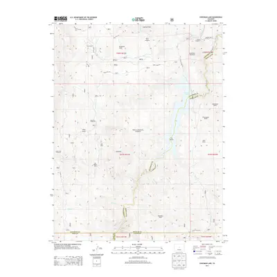
2013 Map of Cheesman Lake
USGS Topo · Published 2013About this map
Cheesman Lake dominates the central landscape of this high-country quadrangle, where the South Platte River carves through the granitic formations of the Pike National Forest. The map documents a rugged transition zone at the intersection of Jefferson, Douglas, Park, and Teller counties. Established ranching operations like the Flying G Ranch and Lost Valley Ranch indicate the long-standing private holdings that persist alongside expansive public lands. These ranch names offer specific reference points for local history and property research within the deep drainage systems of Goose Cr and Wigwam Cr. Recreational geography is well-defined by numerous forest sites, including Spruce Grove Campground and Lost Valley Park, while prominent landmarks such as Sheeprock and Sugarloaf Peak provide topographic orientation across the drainage basins of the Turkey Cr and Wildcat Cr headwaters.
Find a feature on this map
46 named features on this map. Tap any name to fly to it.
Don’t see what you’re looking for? This feature index may not catch every label — zoom into the map to look around manually.
Map Details
Editions of this 2013 Cheesman Lake Map
This is the sole edition of this map. No revisions or reprints were ever made.
Other maps of this area

1893 · Platte Canyon
USGS Topo · 1:125,000

1953 · Denver
USGS Topo · 1:250,000

1954 · Deckers
USGS Topo · 1:24,000

1954 · Green Mountain
USGS Topo · 1:24,000
1954 · Windy Peak
USGS Topo · 1:24,000

1954 · Signal Butte
USGS Topo · 1:24,000

1956 · Mc Curdy Mountain
USGS Topo · 1:24,000

1956 · Tarryall
USGS Topo · 1:24,000

1956 · Hackett Mountain
USGS Topo · 1:24,000
1956 · Cheesman Lake
USGS Topo · 1:24,000