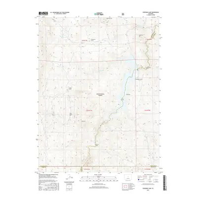
2016 Map of Cheesman Lake
USGS Topo · Published 2016About this map
Cheesman Lake and the South Platte River dominate this 2016 study of the Jefferson and Douglas County borderlands. This landscape is defined by the canyon-cut drainages of the Pike National Forest, where steep ravines like Flickenstein Gulch and Schoonover Gulch feed the central reservoir. The topography is anchored by prominent high points including Sugarloaf Peak and Cheesman Mtn, while the interior provides a detailed look at the Lost Valley Park area. This modern survey maps the critical water infrastructure and recreational access points of the Front Range, tracing the paths of the Wigwam Trail and Gill Trail through the protected forest. The intricate network of seasonal streams like Wigwam Cr and Goose Cr illustrates the complex hydrologic character of this mountain terrain.
Find a feature on this map
38 named features on this map. Tap any name to fly to it.
Don’t see what you’re looking for? This feature index may not catch every label — zoom into the map to look around manually.
Map Details
Editions of this 2016 Cheesman Lake Map
This is the sole edition of this map. No revisions or reprints were ever made.
Other maps of this area

1893 · Platte Canyon
USGS Topo · 1:125,000

1953 · Denver
USGS Topo · 1:250,000

1954 · Deckers
USGS Topo · 1:24,000

1954 · Green Mountain
USGS Topo · 1:24,000
1954 · Windy Peak
USGS Topo · 1:24,000

1954 · Signal Butte
USGS Topo · 1:24,000

1956 · Mc Curdy Mountain
USGS Topo · 1:24,000

1956 · Tarryall
USGS Topo · 1:24,000

1956 · Hackett Mountain
USGS Topo · 1:24,000
1956 · Cheesman Lake
USGS Topo · 1:24,000