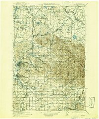
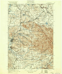
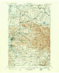
1916 Map of Chehalis
USGS Topo · Published 1941About this map
Centralia and Chehalis anchor this 1916 survey, sitting as significant rail-and-river hubs in a landscape defined by the Northern Pacific railroad and the converging forks of the Newaukum River. The mapping reveals a transition from the level agricultural reaches of Mound Prairie and Chambers Prairie to the timbered foothills of the Snoqualmie National Forest. Industrial and educational landmarks are dense here, featuring the Centralia Seminary, the Union Lumber Camp, and a Fish Hatchery near the Nisqually River. Small rural schoolhouses like Brighton Park School and Logan Hill School are mapped alongside timber-related settlements like McIntosh and Mendota, documenting a period when the timber economy and localized education systems were closely integrated into the Washington interior before modern highway consolidation changed the settlement pattern.
Find a feature on this map
117 named features on this map. Tap any name to fly to it.
Don’t see what you’re looking for? This feature index may not catch every label — zoom into the map to look around manually.
Map Details
Editions of this 1916 Chehalis Map
4 editions found
Other maps of this area

1897 · Tacoma
USGS Topo · 1:125,000

1900 · Tacoma
USGS Topo · 1:125,000

1916 · Chehalis
USGS Topo · 1:125,000

1919 · Mount St Helens
USGS Topo · 1:125,000

1937 · Olympia
USGS Topo · 1:62,500

1937 · Eatonville
USGS Topo · 1:125,000

1939 · Shelton
USGS Topo · 1:62,500

1940 · Tenino
USGS Topo · 1:62,500

1940 · Anderson Island
USGS Topo · 1:62,500

1941 · Meskill
USGS Topo · 1:62,500