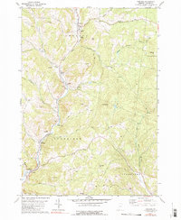
1981 Map of Chelsea
USGS Topo · Published 1981About this map
The First Branch White River carves a deep valley through the heart of Orange County, serving as the primary corridor for settlement and transportation in this rural Vermont landscape. The village of Chelsea sits at the northern end of this corridor, where Jail Brook and Jenkins Brook converge with the river. Further south, the town of Tunbridge is defined by its agricultural character and historic infrastructure, notably featuring several spans such as the Larkin Covered Bridge and the Mill Covered Bridge. The map details a network of family-named heights, including Brocklebank Hill and Whitney Hill, which separate the river valley from the West Branch Ompompanoosuc River headwaters. Local social history is well-preserved through the location of the Fairgrounds and various small rural schools like Meadowbrook Sch and the Tunbridge Central Sch.
Find a feature on this map
45 named features on this map. Tap any name to fly to it.
Don’t see what you’re looking for? This feature index may not catch every label — zoom into the map to look around manually.
Map Details
Editions of this 1981 Chelsea Map
3 editions found
Other maps of this area

1896 · Strafford
USGS Topo · 1:62,500

1919 · Royalton
USGS Topo · 1:62,500

1922 · Barre
USGS Topo · 1:48,000

1924 · Barre
USGS Topo · 1:62,500

1924 · Randolph
USGS Topo · 1:48,000

1926 · Randolph
USGS Topo · 1:62,500

1944 · Strafford
USGS Topo · 1:62,500

1947 · Corinth
USGS Topo · 1:62,500

1948 · East Barre
USGS Topo · 1:62,500

1950 · Glens Falls
USGS Topo · 1:250,000