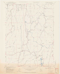
1947 Map of Cherokee
USGS Topo · Published 1966About this map
Cherokee and the surrounding gold-country landscape of Butte County are defined by hydraulic mining history and the deep canyons of the West Branch Feather River. This 1947 survey captures a network of historic water management features, including the Miocene Canal and Upper Miocene Canal, which once served the massive operations at the Cherokee Placer Mine. The terrain is marked by prominent ridges like Clements Ridge and Glover Ridge, with smaller settlements and outposts such as Yankee Hill PO, Nelson Bar, and Parish Camp distributed along the river's winding course.
Find a feature on this map
63 named features on this map. Tap any name to fly to it.
Don’t see what you’re looking for? This feature index may not catch every label — zoom into the map to look around manually.
Map Details
Editions of this 1947 Cherokee Map
3 editions found
Other maps of this area

1888 · Bidwell Bar
USGS Topo · 1:125,000

1891 · Bidwell Bar
USGS Topo · 1:125,000

1891 · Chico
USGS Topo · 1:125,000

1893 · Chico
USGS Topo · 1:125,000

1893 · Bidwell Bar
USGS Topo · 1:125,000

1895 · Bidwell Bar
USGS Topo · 1:125,000

1895 · Chico
USGS Topo · 1:125,000

1897 · Bidwell Bar
USGS Topo · 1:125,000

1912 · Dry Creek
USGS Topo · 1:31,680

1912 · Oroville
USGS Topo · 1:31,680