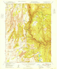
1949 Map of Cherokee
USGS Topo · Published 1949About this map
The West Branch Feather River carves a deep path through this Butte County landscape, separating the high ridges of Clements Ridge and Morgan Ridge from the mining districts to the east. At the center of the local industry is the Cherokee Placer Mine, located just north of the Cherokee settlement, where hydraulic mining legacies are visible in the proximity of Grub Flat Reservoir and Littlefield Reservoir. The 1940s terrain is marked by family-named landmarks and small community centers, including Pentz and the Messilla Valley Sch in the Messilla Valley. To the northeast, the Lassen National Forest boundary touches the area around Deadwood Creek, while the settlement at Yankee Hill PO serves the population living between the river and the northern peaks like Patton Peak. This map records a transition in the local economy as the era of massive placer mining settled into a landscape of small reservoirs and scattered rural schools.
Find a feature on this map
48 named features on this map. Tap any name to fly to it.
Don’t see what you’re looking for? This feature index may not catch every label — zoom into the map to look around manually.
Map Details
Editions of this 1949 Cherokee Map
2 editions found
Other maps of this area

1888 · Bidwell Bar
USGS Topo · 1:125,000

1891 · Bidwell Bar
USGS Topo · 1:125,000

1891 · Chico
USGS Topo · 1:125,000

1893 · Chico
USGS Topo · 1:125,000

1893 · Bidwell Bar
USGS Topo · 1:125,000

1895 · Bidwell Bar
USGS Topo · 1:125,000

1895 · Chico
USGS Topo · 1:125,000

1897 · Bidwell Bar
USGS Topo · 1:125,000

1912 · Dry Creek
USGS Topo · 1:31,680

1912 · Oroville
USGS Topo · 1:31,680