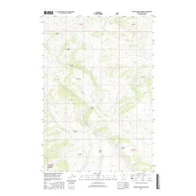
2017 Map of Cherry Creek Canyon
USGS Topo · Published 2017About this map
Gallatin National Forest lands dominate the southwestern portion of this Madison County landscape, where the terrain transitions through a series of high ridges and deep drainages. The map reveals a complex hydraulic system necessary for high-altitude ranching or land management, including the Upper Ditch, Lower Ditch, and the Upper Cherry Cr Ditch that contour around the slopes. Central to the topography is the namesake Cherry Creek Canyon, which carves a path between Wiley Ridge and the heights of Elk Mtn. This 2017 survey documents a modern look at rural Montana infrastructure, highlighting high-elevation thoroughfares like Cherry Creek Rd and High Rd as they navigate the descent from McCormack Pass into the lower Cherry Creek Basin. The drainage network is well-defined, showing how Mill Cr and E Fork Cherry Cr feed into the primary waterways.
Find a feature on this map
30 named features on this map. Tap any name to fly to it.
Don’t see what you’re looking for? This feature index may not catch every label — zoom into the map to look around manually.
Map Details
Editions of this 2017 Cherry Creek Canyon Map
This is the sole edition of this map. No revisions or reprints were ever made.
Other maps of this area

1888 · Three Forks
USGS Topo · 1:250,000

1894 · Three Forks
USGS Topo · 1:250,000

1895 · Three Forks
USGS Topo · 1:250,000

1947 · Bozeman
USGS Topo · 1:250,000

1948 · Bozeman
USGS Topo · 1:250,000

1949 · Anceney
USGS Topo · 1:62,500

1949 · Ennis
USGS Topo · 1:62,500

1949 · Norris
USGS Topo · 1:62,500

1950 · Spanish Peaks
USGS Topo · 1:62,500

1951 · Norris
USGS Topo · 1:62,500