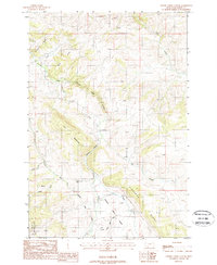
1988 Map of Cherry Creek Canyon
USGS Topo · Published 1988About this map
Gallatin National Forest terrain dominates this Madison County landscape, where complex water management systems like Butler Ditch and Carpenter Ditch parallel the natural drainage of Cherry Creek. The map reveals a high-elevation environment defined by prominent peaks and crossings, notably Elk Mountain and McCormack Pass. Small-scale resource extraction is evident from a labeled Gravel Pit and scattered Prospect markings, suggesting local exploration within the ridges. The intricate network of seasonal flows, including the West Fork Cherry Creek and Mill Creek, underscores the importance of watershed management in this part of Montana during the late 20th century. Local landmarks like Savannah Ridge and Finnegan Ridge provide a detailed look at the land's physical orientation and historical naming conventions.
Find a feature on this map
20 named features on this map. Tap any name to fly to it.
Don’t see what you’re looking for? This feature index may not catch every label — zoom into the map to look around manually.
Map Details
Editions of this 1988 Cherry Creek Canyon Map
This is the sole edition of this map. No revisions or reprints were ever made.
Other maps of this area

1888 · Three Forks
USGS Topo · 1:250,000

1894 · Three Forks
USGS Topo · 1:250,000

1895 · Three Forks
USGS Topo · 1:250,000

1947 · Bozeman
USGS Topo · 1:250,000

1948 · Bozeman
USGS Topo · 1:250,000

1949 · Anceney
USGS Topo · 1:62,500

1949 · Ennis
USGS Topo · 1:62,500

1949 · Norris
USGS Topo · 1:62,500

1950 · Spanish Peaks
USGS Topo · 1:62,500

1951 · Norris
USGS Topo · 1:62,500